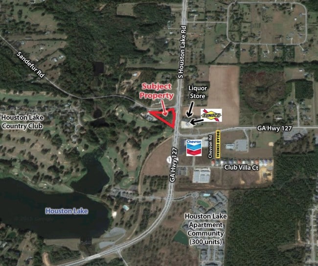
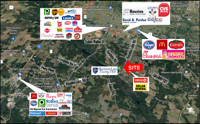
Property Record
Sandefur Rd, Perry, GA 31069

This Property Is For Sale
NEARBY LISTINGS FOR SALE OR LEASE
Property Detail
Sandefur Rd
Warner Robins, GA
Hwy 127 Ho Lk Rd
000810087000
PARCEL 8-R 0.983 ACRE 170/10TH
Commercialacreage
Houston
X
Georgia
13225C0150C
0.98 AC
2024
Perry/Warner Robins
2024
Other Market Areas
021206
DEMOGRAPHICS near Sandefur Rd
1 Mile
3 Mile
5 Mile
2024 Total Population
4,973
20,932
66,548
2029 Population
5,492
23,173
73,132
Pop Growth 2024-2029
+ 10.44%
+ 10.71%
+ 9.89%
Average Age
35
36
37
2024 Total Households
1,728
7,336
23,666
HH Growth 2024-2029
+ 10.24%
+ 10.44%
+ 9.63%
Median Household Inc
$95,286
$92,266
$93,636
Avg Household Size
2.90
2.80
2.80
2024 Avg HH Vehicles
2.00
2.00
2.00
Median Home Value
$190,894
$191,943
$199,247
Median Year Built
2005
2004
2002
Nearby Places
Map Layers
Map Styles
 Street
 Aerial
- Restaurants
- Banks
- Shops
- Fitness
- Groceries
Nearby Properties
Address
Land Use
TOTAL SIZE
Lot Size
Zoning
Address
Land Use
TOTAL SIZE
Lot Size
Zoning
27,696 SF
25.75 AC
C2
Address
Land Use
TOTAL SIZE
Lot Size
Zoning
180,000 SF
146.60 AC
RAG
Address
Land Use
TOTAL SIZE
Lot Size
Zoning
273,000 SF
63.42 AC
C2
Address
Land Use
TOTAL SIZE
Lot Size
Zoning
158,300 SF
43.81 AC
GU
Address
Land Use
TOTAL SIZE
Lot Size
Zoning
91,249 SF
15.85 AC
GU
Address
Land Use
TOTAL SIZE
Lot Size
Zoning
70,500 SF
19.94 AC
GU
Address
Land Use
TOTAL SIZE
Lot Size
Zoning
106,055 SF
22.72 AC
GU
Address
Land Use
TOTAL SIZE
Lot Size
Zoning
85,580 SF
33.60 AC
R2
Address
Land Use
TOTAL SIZE
Lot Size
Zoning
79,638 SF
6.65 AC
C2
Address
Land Use
TOTAL SIZE
Lot Size
Zoning
68,601 SF
7.50 AC
C2
Address
Land Use
TOTAL SIZE
Lot Size
Zoning
38,593 SF
6.49 AC
RAG
Address
Land Use
TOTAL SIZE
Lot Size
Zoning
10,186 SF
26.08 AC
C2
Address
Land Use
TOTAL SIZE
Lot Size
Zoning
11,146 SF
6 AC
C2
Address
Land Use
TOTAL SIZE
Lot Size
Zoning
5,160 SF
1.14 AC
C2
Address
Land Use
TOTAL SIZE
Lot Size
Zoning
30,451 SF
10.19 AC
C2
Address
Land Use
TOTAL SIZE
Lot Size
Zoning
14,500 SF
11.56 AC
C2
Address
Land Use
TOTAL SIZE
Lot Size
Zoning
4,538 SF
50.06 AC
R2 R3 R4
Address
Land Use
TOTAL SIZE
Lot Size
Zoning
31,342 SF
15 AC
C2
Address
Land Use
TOTAL SIZE
Lot Size
Zoning
13,728 SF
5 AC
C2
Address
Land Use
TOTAL SIZE
Lot Size
Zoning
309.40 AC
R1
Address
Land Use
TOTAL SIZE
Lot Size
Zoning
32,805 SF
4.83 AC
C2
Address
Land Use
TOTAL SIZE
Lot Size
Zoning
13,900 SF
10 AC
GU
Address
Land Use
TOTAL SIZE
Lot Size
Zoning
15,949 SF
11.13 AC
C2
Address
Land Use
TOTAL SIZE
Lot Size
Zoning
85.88 AC
R2A
Address
Land Use
TOTAL SIZE
Lot Size
Zoning
53.51 AC
RAG
Address
Land Use
TOTAL SIZE
Lot Size
Zoning
1,080 SF
80.82 AC
R3
Address
Land Use
TOTAL SIZE
Lot Size
Zoning
24,000 SF
7.35 AC
R3
Address
Land Use
TOTAL SIZE
Lot Size
Zoning
268.06 AC
RAG
Address
Land Use
TOTAL SIZE
Lot Size
Zoning
6,000 SF
125.44 AC
RAG
Address
Land Use
TOTAL SIZE
Lot Size
Zoning
13,468 SF
7.04 AC
R3
The World's #1 Commercial Real Estate Marketplace
Connect with us
© 2025 CoStar Group
The information above has been obtained from sources believed reliable. While we do not doubt its accuracy we have not verified it and make no guarantee, warranty or representation about it. It is your responsibility to independently confirm its accuracy and completeness. Any projections, opinions, assumptions, or estimates used are for example only and do not represent the current or future performance of the property. The value of this transaction to you depends on tax and other factors which should be evaluated by your tax, financial, and legal advisors. You and your advisors should conduct a careful, independent investigation of the property to determine to your satisfaction the suitability of the property for your needs.